"Out of a dense and trackless forest"
Revised 9 July, 2017
Joseph Bouchette, a young surveyor and military officer, first visited Toronto harbour in 1792, the year before Lt.-Gov. John Graves Simcoe arrived to establish FORT YORK and the Town of York.
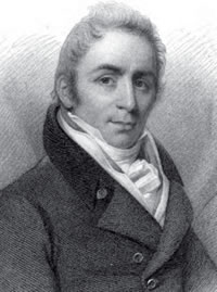
Lt. Joseph Bouchette, circa 1830. Read his biography in the Dictionary of Canadian Biography online.
The following is an excerpt from Bouchette's memoir of his first views of York Harbour in his book, The British Dominions in North America (pub. 1832,
The harbour of York is nearly circular, and formed by a very narrow peninsula... enclosing a beautiful basin about a mile and a half in diameter, capable of containing a great number of vessels, and at the entrance of which ships may lie with safety during the winter.
The formation of the peninsula itself is extraordinary; being a narrow slip of land, in several places not more than sixty yards in breadth, but widening towards its extremity to nearly a mile: it is principally a bank of sand, slightly overgrown with grass; the widest part is very curiously intersected by many large ponds, that are the continual resort of great quantities of wild fowl; a few trees scattered upon it greatly increase the singularity of its appearance; it lies so low that the wide expanse of Lake Ontario is seen over it: the termination of the peninsula is called Gibraltar Point, where a blockhouse has been erected. A lighthouse, at the western extremity of the beach, has rendered the access to the harbour safely practicable by night.
The eastern part of the harbour is bounded by an extensive marsh, through part of which the river Don runs before it discharges itself into the basin.
No place in either province [Lower or Upper Canada] has made so rapid a progress as York. In the year 1795, the spot on which it stands presented only one solitary Indian wigwam; in the ensuing spring the ground for the future metropolis of Upper Canada was fixed upon, and the buildings commenced under the immediate superintendence of the late General Simcoe, then lieutenant-governor, whose liberal and enlarged plans of improvement have materially advanced the welfare and prosperity of the province.
In the space of five or six years it became a respectable place, and rapidly increased to its present importance: it now [1832] contains a population of four thousand souls.
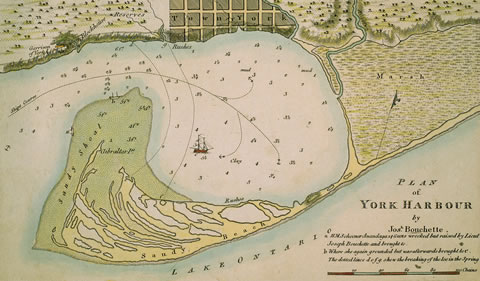
It fell to my lot to make the first survey of York (Toronto) Harbour in 1793. Lieutenant Governor Simcoe, who then resided at Navy Hall, Niagara, having formed extensive plans for the improvement of the colony, had resolved upon laying the foundations of a provincial capital.
I was, at that period, in the naval service of the lakes, and the survey of Toronto Harbour was intrusted by His Excellency to my performance.
I still distinctly recollect the untamed aspect which the country exhibited when first I entered the beautiful basin, which thus became the scene of my early hydrographical operations.
Dense and trackless forests lined the margin of the lake and reflected their inverted images in its glassy surface. The wandering savage had constructed his ephemeral habitation beneath their luxuriant foliage — the group then consisting of two families of Mississaugas — and the bay and neighbouring marshes were the hitherto uninvaded haunts of immense coveys of wild fowl. Indeed, they were so abundant as in some measure to annoy us during the night.
— Notes:
The very noisy "wild fowl" Bouchette describes were passenger pigeons, which flocked by the billions across North America until their extinction at the beginning of the 20th century. For more on passenger pigeons, see the marker "Resting Place of the Wild Pigeons", located at the mouth of Mimico Creek. (MAP CONTROLS: WATERWAYS and environmental features).
Bouchette's description of the "hitherto uninvaded" harbour leaves the impression that this was "empty" and unclaimed land, "virgin" territory ripe for colonization and settlement. His romantic passage, Toronto historian Victoria Freeman has written, "would become the foundational text for the terra nullius interpretation of Toronto’s history and a classic passage in histories of the city, suggesting as it did a pristine landscape, an untouched Eden... the Mississaugas represented as 'visitors' passing through the area from elsewhere, almost as ephemeral as their wigwams, in contrast to the expanding physical presence of the settlement of York."
In fact Indigenous peoples have lived in the Toronto region for more than 10,000 years, most recently the Mississauga Anishinaabeg — now known as the Mississaugas of the New Credit — who kept their council fire at the nearby Credit River. For information on the territorial dispossession of the Mississaugas from the Toronto region, please see The Toronto Purchase of 1787/1805, (MAP CONTROLS: THE GEOGRAPHY OF DISPOSSESSION: Early Indigenous treaties, click the tall mauve rectangle over the Toronto region).
 |
Left: |
 |
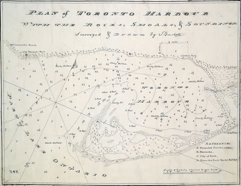
In 1815 Bouchette drew this map, titled simply Plan of York Harbour. This 1815 map is an adaptation of the Plan of York Harbour surveyed by order of Lt. Govr. Simcoe, drawn in 1793 by deputy surveyor Alexander Aitken. |
Among the differences among the maps: Aitken's showed Lt.-Gov. Simcoe's original 1793 10-block Town of York; Bouchette's 1815 version showed the town as expanded to Peter Street by Peter Russell in 1797. See Aitken's map in the tab Alexander Aitken's 1793 map: the first official plan.
Below: J.G. Howard's 1840 watercolour Cedar Swamp illustrates the looming forests and "untamed aspect" of early Toronto described by Bouchette above. (City of Toronto Toronto Culture, Museums and Heritage Services, 1978.41.100.)

Below: Elizabeth Francis Hale's watercolour Part of York the Capital of Upper Canada on the Bay of Toronto in Lake Ontario, 1804 (Library and Archives Canada, C-34334). The picture shows the Toronto Bay waterfront during the earliest days of York. It looks east along Palace Street (now Front Street East) — from today's Jarvis Street at the left, to the military blockhouse (at the mouth of the Don River) in the distance. Based on an 1803 watercolour by Edward Walsh, the pictures are gorgeous but not entirely accurate. There existed, for example, a bluff of 10 to 30 feet dropping down to the lake, and it could take a few minutes to climb down and actually reach the water's edge— not the flat stroll portrayed in both the Walsh and Hale pictures.

Right:
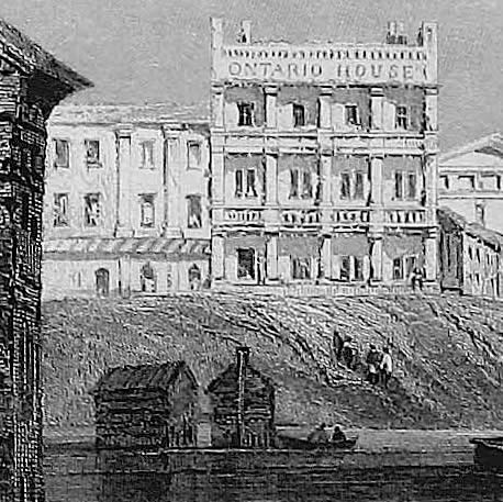
this detail from "Toronto", a drawing by W.H. Bartlett, shows more accurately the shoreline bluff and the climb from the lake up to street level. From Canadian Scenery Illustrated,
Vol. 1, 1842.
 The original town was only five blocks wide, between today’s George and Berkeley Streets,
from Front Street on the lake and two blocks north to Duke Street (now Adelaide Street East).
The original town was only five blocks wide, between today’s George and Berkeley Streets,
from Front Street on the lake and two blocks north to Duke Street (now Adelaide Street East).
A blockhouse — with flag, centre-right in Mrs. Hale's painting — located east of the town, at the mouth of the Don River, reminds us that Toronto was first and foremost a military base. Two miles west was Fort York, with another blockhouse, located at what is now the foot of Bathurst Street.